Your aerial imaging specialist
We deliver top-quality aerial imagery that exceeds customer expectations.
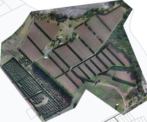
At Digisky, we understand that mapping a farm or orchard can be a complex and time-consuming task. That’s why we make it easy for you by providing high-resolution ortho-rectified images of your property. Our ortho-rectified images are aerial or satellite images that have been geometrically corrected to remove terrain relief, lens distortion, and camera tilt, resulting in a more accurate representation of your land. These images can be easily imported into GIS software for more detailed planning, drawing, and measurement purposes.
Our ortho-rectified images serve a multitude of purposes beyond mapping and planning. They are a valuable tool for tracking changes over time, such as crop growth, infrastructure development, or changes in land features. Moreover, they are instrumental in environmental monitoring, disaster response, and land management efforts.
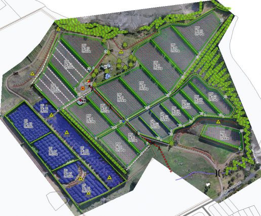

Beyond providing ortho-rectified images, we offer customized maps tailored to your specific requirements and property attributes. These maps can include relevant features such as hazards, access driveways, loading bays, and canopy areas. Our custom mapping services allow you to gain a comprehensive understanding of your property’s layout and features, empowering you to make well-informed decisions.
In addition to mapping services, our aerial images can also be used for monitoring tree height and canopy volumes. This information is crucial for assessing pruning effectiveness and estimating crop yields. By having access to accurate measurements of tree height and canopy volumes, you can make informed decisions to optimize orchard management and harvest planning.
New Zealand’s significant elevation changes can impact the resolution of aerial images. To ensure consistent resolution throughout each flight, we employ terrain-aware flight plans. These plans automatically adjust the aircraft’s altitude to maintain a constant elevation over the designated area, resulting in a standard ground sample resolution of <4 cm per pixel.
We offer a range of output options for our aerial images, including GeoTIFF, Jpeg, and KMZ (Google Earth overlay). Additionally, our maps can be output in PDF or Shapefile format. Our advanced flight planning and image processing techniques allow us to provide high-quality aerial images of even the most complex and varied terrain.
In conclusion, Digisky’s mapping and monitoring solutions offer a comprehensive and valuable resource for farmers and orchard owners seeking accurate, detailed, and up-to-date information about their land. With our high-resolution ortho-rectified images and customized mapping services, you can enhance your property management, planning, and decision-making processes.
Digisky is proud to have had the opportunity to present our results at the 10th World Avocado Congress, held in Auckland in April 2023. Our collaboration with Seeka, a longtime client for mapping, allowed us to showcase the power of our multispectral mapping technology for avocado orchards. Additionally, we recently worked with a research institute in Latvia to conduct a study on the different applications of NDVI, NDRE, and GNDVI over avocado orchards. The study not only focused on identifying areas that required more attention, but also included an accuracy assessment over tree measurements and their apparent volume assessment, in order to predict the yield or fruit crop. We are excited to continue providing cutting-edge solutions and innovations for our clients, and to help drive agriculture practices forward.
“Use of high-resolution drone imagery for crop estimation, health and size of GEM® and ‘Hass’ avocado trees in New Zealand”
We deliver top-quality aerial imagery that exceeds customer expectations.